
Monday, November 26, 2012
Thursday, July 12, 2012
Arrive Chocowinity 11 July
I sailed almost
all the way back up the Pamlico River. There were rain showers
off-and-on, but the rain was warm, and no strong wind. In fact, the last
three days have been the most pleasant for the entire trip. Gosh it has been hot. Except for the heat, the most bothersome thing has been flies. Of course there was that really bad day, but most of the
time I kept a fly swatter handy, and every few minutes would have to use it. I guess it was the time of year.

Time to put Advent II to bed for awhile and become a dirt-dweller again. The fact
of life are calling me. Thank you for going along with me. And if you have not been getting messages from the boat email check your spam folder to see what is there. And in a day or so there will be some pictures on Adventtwo.blogspot.com
See the following picture. I bought it new just before I left.
Bill Doar

Tuesday, July 10, 2012
Monday, 09 July 2012 was a Dismal day
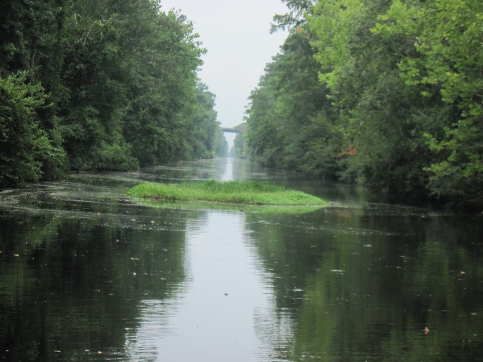 I have long said that the Waccamaw River north of Georgetown SC was the
most beautiful place on earth. Not any longer. Going upstream from
Elizabeth City, the Pasquotank River is even more beautiful than the
Waccamaw. As you turn and wind your way upstream the river gets narrower
and the lush banks and trees get closer. Occasionally you have to pick
your way around a floating island. And then, about 15 miles along, you
get to the locks which lift the boat about 10 feet, and "beautiful",
"spectacular", becomes "stunning". The Dismal Swamp Canal is beautiful
beyond description. The banks have cascades of vines from the trees to
the water. Virgin forests and big trees on both sides. It is narrow, and
the trees grow right on the canal banks, their limbs extending over the
canal, sometimes more than half way. I had to be constantly aware of
what was above me. I had to drive a serpentine course, dodging
overhanging limbs. Walt Disney could not have created a more spectacular
location. It truly is a national treasure.
I have long said that the Waccamaw River north of Georgetown SC was the
most beautiful place on earth. Not any longer. Going upstream from
Elizabeth City, the Pasquotank River is even more beautiful than the
Waccamaw. As you turn and wind your way upstream the river gets narrower
and the lush banks and trees get closer. Occasionally you have to pick
your way around a floating island. And then, about 15 miles along, you
get to the locks which lift the boat about 10 feet, and "beautiful",
"spectacular", becomes "stunning". The Dismal Swamp Canal is beautiful
beyond description. The banks have cascades of vines from the trees to
the water. Virgin forests and big trees on both sides. It is narrow, and
the trees grow right on the canal banks, their limbs extending over the
canal, sometimes more than half way. I had to be constantly aware of
what was above me. I had to drive a serpentine course, dodging
overhanging limbs. Walt Disney could not have created a more spectacular
location. It truly is a national treasure.  Today, Tuesday, is a
really good day for boating. The heat has finally subsided, high only in
the 80's, the sun is not baking down on me, and periodically I get a
fresh water washdown. I am on my way to the upper Alligator River for
tonight, then tomorrow on to Chocowinity.
Today, Tuesday, is a
really good day for boating. The heat has finally subsided, high only in
the 80's, the sun is not baking down on me, and periodically I get a
fresh water washdown. I am on my way to the upper Alligator River for
tonight, then tomorrow on to Chocowinity.Bill Doar
pictures from Bill


Friday, July 6, 2012
Tuesday 03July
The Lord of the Flies, or, Lordy! the Flies!
Before it gets too hot in the cabin to be fun I will try to write up my last two days. High today on the bay is to be low 90's, which is a lot better than the low 100's. Of course, the average for this date is 86 degrees, so we are well above normal.
Will was excited when he learned that I was stopping at The Great Wicomico River. The geologic structure he is studying emerges to the surface at the Wicomico, as described in a 1901 publication. That is the Wicomico River. Not The Great Wicomico, or even another river, the Small Wicomico. But when I turned around I had the opportunity to go to the Wicomico, (or the Not-So-Great Wicomico as Normandie calls it.) Well it is a beautiful river. And I could have anchored anywhere along it if I wanted a longer stay. I motored a long way up the river to the Wicomico Creek, then went up the creek for a mile or so, to the co-ordinates Will had given me. His geologic outcroppings, at high ground along a beautiful river, had been developed. I took pictures, but unless one goes there and digs holes, nothing interesting can be gained. He and I both expected it to be like the bluffs on the Tar River between Greenville and Washington. So after discussing it with him on the telephone I turned around and headed back downstream.
The day started with another save-yourself-first-then-look-out-for-the-boat thunderstorm. Will had seen it coming and had alerted me via telephone text. It was not as bad as the other two, but I was in exposed water and it lasted for 2.5 hours. I was glad when it ended. I was mightily tossed around. Then, after a pleasant cruise up and down the river the flies arrived. Many, many housefly sortta creatures, which would draw blood if one sat on the skin for about 20 seconds. And there were hundreds of them. Insect repellant only worked while it was still wet on my skin. I could protect myself with a swatter as long as I continually used it, at a rate of about one kill every five seconds. I had piles of dead flies on the floor, and many times the swatted fly on my leg would fall into my shoe. I had dead flies everywhere. At one point I had to sign off a telephone call with Normandie because I needed that hand to swat flies. It was spectacular. I had to control myself to keep from becoming frustrated. After I anchored I put up the screens and proceeded to kill them inside the cabin, which worked. At least that worked. And wonderfully, at nightfall I was not bothered on the foredeck.
Today I have only occasional flies, controlled with the swatter. Give Thanks! And another reason to give thanks is that I have wind, and am actually sailing! I am on the Eastern Shore, and the wind is forecasted to be from the south at 10 kts. If this continues I will be able to go southwest, and cross the bay. I may end up at Deltaville for the night. That is where we picked up Bailey's new boat for a wonderful trip down to Sunset Beach. The last time I sailed to Deltaville I spent several hours aground with a crab pot on my propeller. So Deltaville has lots of memories for me.
Tomorrow's forecast is for southwest wind at 10. I may be able to sail diagonally across the bay to Cape Charles, or maybe down to Norfolk. We'll see how it turns out. Except for the first day when I sailed down the Pamlico and up the Pungo, I have motored all day every day. Right now I am sailing a comfortable 3 knots. This is really a good change.
Bill Doar
P.S.
It was an absolutely glorious sail across the bay to Deltaville; the kind of day I wish everyone could have been with me. I want to give this to everybody reading this (not at the same time, however). The wind was about 10 kts, the bay smooth, and Advent II "in her groove". It was wonderful. After all the motor-motor-motor in the blazing hot, it was just gliding along, and the breeze was only pleasantly warm; I never got hot. It was simply wonderful. No flies, a swim, shower, and sundowners as the full moon rises.
Tuesday, July 3, 2012
Sat June 30 Solomon's Island
A few days ago, after motoring over glassy seas in 100 degree heat, I
anchored and went for a much needed and much appreciated swim. Gosh it
was good. After I got out I saw the first jellyfish. Big and sinister,
long and stringy. Then I saw another one. Well darn. Taking away my
afternoon swim is like taking away my rum and sunset. Well now, that
really limits me.
Solomons Island is a lot like Oriental, NC. Lots and lots of boats. Various deep creeks wind around, with marinas one-after-another. There must be thousands of boats here. This morning I fueled, watered and iced. I motored all day every day from Coinjock NC where I last fueled, and didn't use but 25 gallons of diesel. I am happy about that. I also used 21 gallons of water in those six days (not so happy-the allocation was 2 gallons a day), and still had ice in the cooler (happy). Yesterday, after another of those 100 degree days, I got to Solomons Island, on the Patuxent River. I anchored out in the river instead of in the little enclosed anchorage behind the island, to get what little breeze there was. It was reasonably cool when I went to sleep after sunset on the foredeck, about 21:30. I was awakened about two hours later by a powerful thunderstorm. The Pax River Navy Air Station, which is within sight across the river, recorded 30 to 50 kt wind with higher gusts. I got it all. I dragged anchor for the first time, and the motion of the boat was so severe I couldn't do anything about it. Fortunately I could follow my "progress" on the chartplotter, and could tell when I was about to get into trouble. When the storm eased up I had dragged about 2/3 the way across the two mile wide river, right up close to the Air Station. On the trip up I have been using the drifter whenever there was enough wind. I had it furled in front of the genoa, but while I know how to secure a genoa in case of bad weather, I apparently didn't know how to secure the drifter. She got loose and shredded. My first dragged anchor and my first shredded sail. I know why the sail got loose, but I do not know why the anchor did not hold. It is sized for a 60 foot boat, and I had out 100 feet of chain in 15 feet of water. I have gone from not knowing anything about boating and being humble, to having a lot of experience and knowing quite a lot, and now back to being humble. Severe thunderstorms are forecasted again for tonight, and I am quite apprehensive.
Speaking about being apprehensive, I have been quite apprehensive about my trip back home, trying to sail down the Chesapeake against the prevailing southerly wind. I need to be back on the 17th, and have been scheduling departing from Annapolis on the 9th. I have not been at all secure that I could do that. Well yesterday I learned that Ted, my host aboard the Liberty Ship "John W Brown", would be out of town next week. That eliminated my excuse for going to Annapolis, and after some consideration, decided to not continue up the Chesapeake, but rather start heading back to North Carolina. I had violated one of the rules of cruising: I can give a date (to meet someone), or I can give a place (to meet someone). But I can not be at a certain place on a certain date. When I met Normandie a few months ago in Turks & Caicos, I had two weeks of contingency to make sure I was there when she got there. I had only one day contingency on the 9 day trip back to NC. When I decided to not keep going but to start working my way back, I felt at peace. The apprehension was gone. Now I have 15 days to make it back, and on the way will be able to swim in the fresh waters of the Albermarle Sound, without jellyfish.
Bill Doar
Occasionally check: Adventtwo.blogspot.com There is stuff there that I don't send to everybody, like pictures.
Thursday, June 28, 2012
Thursday 28 Jun
44 nm today, most of it motoring against 1 kt of current. The last hour a
nice, unforecasted 12 knots came out of thr south. Up the drifter, off
the engine, and I sailed at 5 kts all the way to The Great Wicomico
River. I know why there is such a big deal about saying "The Great".
There are two other Wicomico Rivers. The Little Wicomico is about 5
miles north, and the Wicomico, just plain Wicomico, is 45 miles
northeast. It caused confusion because Will asked me to check out a
geological feature on the Wicomico for him. Sorry Will, wrong Wicomico.
It is a nice anchorage, and I have 20 kts forecasted for tonight. This
is a good place for it.
40 nm tomorrow to Solomons Island.
Time for a highly anticipated swim. And then I have some reading to do. What and Where (on a highway map) is Solomons Island? It is one of those names I know but don't know why.
40 nm tomorrow to Solomons Island.
Time for a highly anticipated swim. And then I have some reading to do. What and Where (on a highway map) is Solomons Island? It is one of those names I know but don't know why.
Wednesday 27 June
This morning started clear, crisp and cool, about 60 degrees, with a
gentle breeze from the north. I can deal with a gentle breeze. I made a
good departure, and went directly across the river to the Norfolk side
and took a picture of the tall ship "Virginia". The next time I get
internet I will look it up so I will know what I saw, and send you the
picture. Then up past all the navy ships and out into Hampton Roads. The
wind was a little stronger than gentle so I decided to see what the bay
was like to see if I could proceed. When I got out to Thimble Shoals
the wind was from the north making whitecaps. I referred to the Waterway
Guide I bought just before I left (and glad I did) and found that I
could anchor in Hampton. I motored into the narrow Hampton River,
(didn't know that there was a Hampton River,) past Hampton University
(didn't know there was a Hampton University) (Hampton Sidney ?)and lots
of upscale docks and restaurants, to a small anchorage. It would be fine
if I wanted to "town" (I just invented a verb), but all I wanted to do
was anchor. The Waterway Guide also said that there was an anchorage out
where the tunnel comes in from Norfolk. That was perfect. It is large,
open, sheltered from west and north wind (forecasted for tonight), and
easy to get out of. I still plan to go to Reedville tomorrow. It will be
about 50 miles, and the winds are supposed to be light from the west,
so it should be no problem. So now I am happily doing boat chores. Do a
few a day and the boat looks better and better.
Lone, Bill
Maybe I should make that
Love, Bill
Lone, Bill
Maybe I should make that
Love, Bill
Tuesday, June 26, 2012


Monday, June 25, 2012
June 25 email
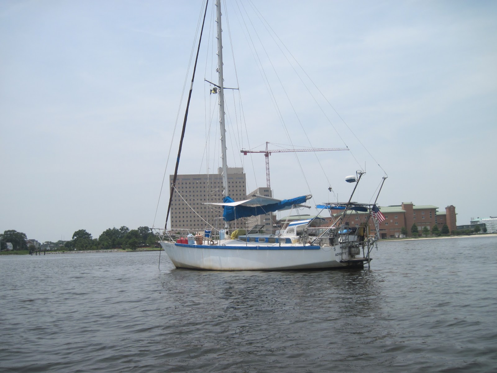
I am anchored at Hospital Point, in Hampton, across the
river from Norfolk. I used to think that “Hospital Point” was a nic-name, but
that is the official name, and true to its name, there is a huge hospital
complex looming beside the 100 year old original. The trip up had a little of
everything (except cold). There was beautiful sailing down the Pamlico and up
the Pungo. Then a blazing hot 20 mile trip through the canal to a beautiful
anchorage with three other boats in the narrows of the Alligator River, with
strong and gusty wind, that kept me in the cockpit for the evening. I was at
anchor, but I was not far from the Alligator River Marina, one of my favorites.
I stopped there with Barbara and Bailey when they were bringing their brand new
boat down from Deltaville. It is a typical eastern North Carolina place with a convenience
store, small restaurant, and everything needed at a marina. And it is well
protected from bad weather. Just ask Normandie when she, Marion, Marjorie and
Anne came down from Virginia. All the
other boats were hunkered down , but the intrepid ladies weathered the storm
and were the first ones through the bridge. I love the place, and always stop
when driving to the Outer Banks.
The next
day was motoring through the crab pots up the Alligator River and across the
Albermarle Sound. It wasn’t as hot, but was dead calm, and I had to drive the
whole way dodging the pot floats. There are no anchorages at convenient
distances from Norfolk, so I stopped early just north of the Albermarle. At sea
I can spend a lot of the time letting the boat drive herself while I read or do
chores. On the ICW I have to stay in the cockpit all the time; just dash below occasionally
to do something quickly before the boat gets into trouble. It is really quite
tiring. I was really ready for a swim that evening.
Then the
last long day was motoring across the Currituck Sound, stopped for fuel at
Coinjock, then through the Chesapeake Canal with nine drawbridges and a lock.
The bad thing about it was that some of the bridges only opened on the hour,
which can really mess up a schedule. You hurry, hurry, hurry to make the
opening, miss it, and have to wait an hour. The most interesting that day was
going up the Elizabeth River where they do all the heavy ship repairs. Really
interesting commercial, shipping, and Navy craft of all sorts. There was what
looks like a new aircraft carrier (Warship 75 – anybody know what it is?) There
was also a Navy ship that was completely shrouded except for the bridge. When
Advent II said “Hello” the warship said “Don’t look at me.” I got to Hospital
Point about 19:30, with about an hour remaining of daylight. These long days
make for long traveling days.
Today,
Monday, I just tried to sort out the boat some, and it has taken all day. This
is a general plan:
Tuesday: 35 nm to Seaford Va., where we were living when
Grayson was born. Normandie and I have anchored there before, within sight of
the house.
Wednesday: 30 nm to Reedville, at The Great Wicomico River. (I
love the name.) The last time I was there I anchored near the last menhaden
factory left on the east coast. About 10 years ago the last one in North
Carolina, in Beaufort, closed.
Thursday: 40 nm to Solomons Island, in the Patuxent River. I
am looking forward to visiting there for the first time.
Friday: 40 nm to Annapolis. I don’t have any idea what to do
there. I’ll build the dinghy and go ashore to see what happens.
Normandie
spent three afternoons last week windsurfing and kiteboarding, while I was
sweltering in an open cockpit. I was having August weather, she while she was
having April weather. Ride one for me, Normandie.
Now I will
hook on to a wifi and send this. Cheers!
A little later- I have just experienced what was probably
the worst storm ever. I guess at 60 kt wind for 30 minutes, hail, etc. The boat
about 100 feet behind me took a direct lightning hit. I have never seen a boat
bounce and veer so much. It would veer to one side, then the wind would lay it
over dramatically. Very spectacular. I was very happy at how well Advent II
did. I was comfortable the whole time. The good thing was that it happened
during daylight.
Bill
June 23 email
Yesterday evening we had strong gusty wind. Choppy and veering even in
the narrows at the south end of Alligator River. No sitting on deck,
almost uncomfortable in the cockpit with the wind blasting first one way
then the other. Today the Alligator River is calm, slick, and hot.
June 22 email
The forecast was for 15-20. It is blowing that now, here. But even with
the wind it is really hot. I am sitting here trying to not touch
anything. As soon as I send this I am going to jump in the water.
Tomorrow I will cross the Albermarle and Currituck, then stop short of Coinjock. Then Sunday try to make it to Hospital Point anchorage.
Sent with hot sweaty love,
Bill
Tomorrow I will cross the Albermarle and Currituck, then stop short of Coinjock. Then Sunday try to make it to Hospital Point anchorage.
Sent with hot sweaty love,
Bill
Thursday, April 19, 2012
Dispatch, Thursday 19 April
30 nm from Wrightsville Beach
I got to Frying Pan Shoals, off Cape Fear, just about the time the weak cold front got here. Not bad weather, a few sprinkles and only 12 knots of wind, but the wind went from south-west to north. Now I am headed north to Wrightsville Beach, straight into the wind.
This is the most important thing I have learned on this trip: I have had a problem because when I make bread, as soon as I take it out of the oven, I eat one entire loaf. I have learned how to not do that. Make really bad bread.....
ETA is 16:00 this afternoon.
Bill Doar
s/v Advent II
Wednesday, April 18, 2012
Dispatch, Wed 18 April
60 nm east of Charleston
I am still becalmed, overcast, but now with no current. The Gulf Stream turns east out past Hatteras and I have crossed it and now just have to go the 100 nm up the coast. Also, for some reason it is quite choppy, which makes it uncomfortable onboard. The forecast gives me no reason for optimism. "Stationary front, today light and variable, Thursday: south, south-west to west 10 kts. Friday west 10 kts, Sat & Sun gale force wind. I want to give that gale one day extra margin, so I want to get to Wrightsville Beach not Friday but Thursday. That is tomorrow. After the rough time I had going south against the wind and current, I very much wanted to sail cleanly all the way home. I made it this far, but now, as much as I don't want to, it will be on with the motor. I have 110 nm to go, so at 4 kts I will arrive tomorrow afternoon. Of course, if that south-west wind forecasted is strong enough to sail in I will take advantage of it.
There were two more episodes of strange waves yesterday, spaced maybe 30 minutes apart. In each the waves were bigger and more widely spaced, but each jiggled the boat like the first, but slower and harder each time. None of it was bad, just a particular side-to-side juggle. Also, purely coincidental, some birds came. Not sea birds but three were little finch type and one swallow type. They seemed to be trying to land on the erratically moving boat. Two went inside the cabin. I found one dead this morning.
The bread was made with 100% whole wheat. Really tough, hard, and not much taste. I think I learned something.
For now it is motor, motor, motor over the slick, somewhat choppy ocean.
Bill Doar
s/v Advent II
Later - The chop went away, or maybe I went away from the chop. No traffic on the radar, no traffic on the AIS, no traffic on the horizon. Nothing but a glassy, softly undulating ocean.
17:30 - After motoring all day under trisail, with drifter and poles out ready for light south-west wind, the wind came, but south-east at 12 kts. Poles in, genoa out, and I am sailing smoothly at 5.4 beautiful knots.
Dispatch, 17 April, Waves
I was sitting in the cockpit reading,
the boat slowly rotating in the still, glassy ocean. I heard something
and looked up. Coming toward me were waves. Coming in a line as far as I
could see in both directions. Small waves, not over 2 feet, but many,
very close together, the kind of chop a swift running tide will make.
The boat started jerking and bobbing about. Not badly, hundreds of 2'
waves converging on the boat will not make it buck badly, but it was
bucking around. Still no wind, and my rate of drift had not changed. The
waves moved off to the south west and I could see slick water in front
of it as it moved away from me. They passed on by, and now the ocean is
slowly going back to the way it was before...An earthquake?
Bill Doar
s/v Advent II
Bill Doar
s/v Advent II
Dispatch, Tuesday 17 April
100 nm east of Brunswick Georgia 200 nm to Wilmington
Today I turned the corner. I have been heading northwest (in fact, north-northwest) to get into the Gulf Stream, for two reasons. The first is to ride the current. It will give me a free boost. The second reason is in case a cold front or low pressure cell moves this way. If something bad comes I can simply head straight west for about 20 nm and be out of the Gulf Stream and its really bad conditions in a north or northeast wind.
Well here I am, smack in the Gulf Stream and all its terrors. The wind stopped. Nothing. Smooth glassy seas. One thing, it is comfortable. Nothing but a gentle rolling swell. This is what is hard to believe... boat speed through the water zero. GPS boat speed, 4.3 knots! This entire mass of glassy smooth water is moving 4.3 knots. I am happy about that. The boat is going where I want to go and I am not doing a thing. It jhas given me an opportunity to try different ways of rigging a light air sail, the drifter. It is up right now, poled out, ready to catch the smallest breeze when it comes. For now, I am going to make some bread.
BIll Doar
s/v Advent II
Dispatch, Kiteboarding
 When something makes me really happy I want to share it.
Kite boarding is done with a board similar to that for snowboarding or wakeboarding in that you stand on a board and go left or right, down a hill, being pulled by a boat, or in the case of kiteboarding, being pulled by a kite. The kite may be 8' high and 20' wide. In addition to power lines that are attached to a harness strapped around your waist and pull you along, there are control lines attached to a control bar used to steer the kite. You need to learn how to control the kite, and to control the board.
The first time I saw kiteboarding was about 2002 and I was captivated. All it takes is a kite that will fit in a backpack, a board, and a harness to go around your waist. It is not brute power like waterskiing or wake boarding; it is using the wind to pull you, skimming along the surface of the water. To me it was exotic, and I knew that I could learn to do it. Normandie bought the first kite "trainer" maybe 4' wide, and I took it when I went to Houston. On the weekends I would take it to Galveston Beach and fly it, learning the feel of control. After a year I graduated to a next larger size that Normandie had been learning with. This one was large enough to hurt you if not handled correctly.
 The next step is to fly a real kite from the
land. I was back in North Carolina by then and we would take the Bronco
to the beach down from Carolina Beach where nobody else was, and attempt
to fly it. After many crashes and tangled lines both of us were getting
good enough for the next step, having the kite drag you through the
water without a board; flying and controlling the kite while being
dragged. I took some lessons in 2010 and 2011. I was beginning to start
learning how to get up. Throughout this process Normandie was a year
ahead of me. One reason was that she started learning before I did, the
other was that it takes wind of about 16 knots for me to get up, she can
get up in 12 knot wind. Many times I was standing on the beach watching
her, not pink with sunburn, but green with envy. In 2011 I realized
that, not being a wakeboarder, I had no idea what to do after I got up.
So I started learning how to wake board. We rigged a vertical pole on
Normandie's boat for Wilmington and the Wayler For Chocowinity, and took
up wakeboarding. (Normandie named the Boston Whaler the "Doarway-ler",
Shortened to "Wayler".)
The next step is to fly a real kite from the
land. I was back in North Carolina by then and we would take the Bronco
to the beach down from Carolina Beach where nobody else was, and attempt
to fly it. After many crashes and tangled lines both of us were getting
good enough for the next step, having the kite drag you through the
water without a board; flying and controlling the kite while being
dragged. I took some lessons in 2010 and 2011. I was beginning to start
learning how to get up. Throughout this process Normandie was a year
ahead of me. One reason was that she started learning before I did, the
other was that it takes wind of about 16 knots for me to get up, she can
get up in 12 knot wind. Many times I was standing on the beach watching
her, not pink with sunburn, but green with envy. In 2011 I realized
that, not being a wakeboarder, I had no idea what to do after I got up.
So I started learning how to wake board. We rigged a vertical pole on
Normandie's boat for Wilmington and the Wayler For Chocowinity, and took
up wakeboarding. (Normandie named the Boston Whaler the "Doarway-ler",
Shortened to "Wayler".)
A world class kiteboarding beach has steady, dependable wind, access, and a vast area of water waist deep. Only experts can kiteboard in deep water. You need to be able to stand up to launch the kite and prepare to start. Normandie found such a place in Turks & Caicos. Every year she and her mother go off for an adventure. This year it was Turks & Caicos. I would take the boat down and meet them there. Some years back a European couple went to Turks & Caicos to go kiteboarding. They enjoyed it so much they bought a small "Villa" complex, nestled in tropical lushness, on the kiteboarding beach. They have eight units (efficiency apartments) in two buildings, with pool, hot tub, etc. Normandie had gotten one of the units for the week she and Marjorie would be there. I would leave "Advent II" in an anchorage for the week.

This trip has been an absolute success. Thank you Normandie.
Bill Doar
Monday, April 16, 2012
Dispatch Monday 16 April
120 nm east of Daytona Beach
306 nm from Wilmington
Yesterday the wind was 15-20, and choppy seas from the high winds the several days before. Today the wind and seas are down. I have been comfortably sailing wing 'n wing all day. It is really nice to just sit back and read. All I have to do is stand up occasionally and look around. I sometimes forget what I am doing and just look out over the ocean several minutes. Good wind, comfortable seas, and a positive current makes this really good ocean sailing.
Every four hours I send in my position via satellite. The program puts my position on a map that you can zoom in or out to see the entire ocean. It is really a lot of fun. If you want to see my track go to: adventtwo.blogspot.com
Bill Doar
s/v Advent II
Dispatch Easter 2012, Part II

That started a discussion that lasted 30 minutes, 45 minutes, maybe an hour, much too long for a busy priest on Easter morning. We talked about many things. About his parish: he explained that the parish is a geographic stretch of Eleuthera, and that he had six churches in the parish. His father was also a priest, and they shared the duties. We talked about his congregations, the Dioces of Bahamas and Turks & Caicos. The Province of the West Indies, The Anglican Communion, The stepping down of the Archbishop, Rowan Williams. (The rector went to school in England, at the school where Rowan Williams did his undergraduate work. He would come back and give seminars, etc.) We discussed the American Episcopal Church, and the effects actions of the American church has on his parish, the diocese, and the worldwide communion. He said that all he, and his people, know about the US church is what they see on big cable networks, CNN and MSNBC. And the
consternation felt at what they saw. He asked me to tell him what was really going on, what is the American Episcopal Church? We talked, and talked, and talked; personal, conceptual, spiritual, biblical, liturgical. When his time was getting short he dumbfounded me by asking if I would like to read one of the lessons at the 11:00 service! It was perhaps one of the greatest honors I have ever received. The thought of being asked to read for the most important service of the year.... I declined, and am glad I did, because I would have usurped one of his people who were already being honored by reading. Later, in the service, seeing the people who read, my decision was reinforced. As we parted, he took my hand, and said,"Thank you for coming here. Your presence tells us that we are OK, that the rest of the world respects us, and that we are not alone. You do not wear a collar, but you are a minister, a missionary of the Church."

Alleluia, Christ is risen!
Easter 2012
Bill Doar
Dispatch Easter 2012, Part I
I went ashore at first light. I had anchored just offshore at New Bight, Cat Island, Bahamas and planned to go 70 nm that day up to a safe anchorage at the south end of Eleuthera. Wind from the west was expected; Cat Island has no protection from west wind.
Father Jerome was an architect, a dog breeder, mule skinner, merchant seaman, missionary priest, and monk. He came to the Bahamas in the early 30's as an Anglican priest, and settled in the islands. A major hurricane had destroyed the church buildings, and being an architect, he rebuilt the buildings stone on stone in the fashion of medieval buildings, with arches and buttresses, that would withstand future storms. On Long Island alone he built seven Anglican churches. He went to Rome to study, and three years later came back a Catholic priest, and in Clarence Town, Long Island built a bigger and better Catholic church on the hill next to his Anglican church. He was "reassigned" to Australia. Some years later he "retired" and moved back to Cat Island, where, atop of the highest place in the Bahamas, he built his Hermitage.
 |
| The Hermitage |
I am still surprised to find paved roads in the more remote Bahamian islands. There was even a paved road with a sigh, "The Hermitage". In the morning twilight the road landscape was almost foreboding. There were open areas with nothing but rock outcroppings, interspersed with sinkholes. In the water these holes are called "blue holes" because they are very deep, hundreds of feet, and are dark blue compared to the waters all around. On land no telling how deep these holes were. They looked like vernicle caves. Some were 30' across, others only 6'. About a mile farther the road ended at the trailhead up to The Hermitage.
I could see it as I looked east into the morning sky, high atop the hill "Mt Alvernia". There were Latin inscriptions on the stone arched gateway. A bit up the trail there was a monument, "Jesus Christ Condemmed to Death, then farther on another, Jesus carrying the cross, a stone carving, Stations Of The Cross.

Father Jerome made each of them. Now the trail was steep, in one place a series of 12 steps cut into the stone. Jesus falls, Jesus sees Mary. When I got close there was a plate of metal hanging from a tree. Instructions are to strike the metal with a stone to announce your presence. I announced my presence to the early morning mountaintop. There before me was the final residence, and the final resting place of Father Jerome. It looked like a monastery, on a small scale. There are really only three rooms, and these only large enough for one person. But it was an architectural work of art, and built by one man's hands. At first it was a curiosity, but after a few minutes I began to feel that I was on holy ground. The primary part of the small complex was what looked from the outside like a chapel, and in fact is a chapel, but only large enough for one person. There was the altar, with the rising sun in the window. He oriented the chapel so that altar faced the rising sun at Easter. There was one kneeling chair. I visualized the man starting and ending his day with prayer.
The sun was above the horizon, and I had miles to go, I did not linger. As I went down the hill, past the 14 Stations, I was overcome with the realization that I had walked the Way of the Cross, on Good Friday, in the steps of a holy man.
God Bless You All
Bill Doar

Dispatch Sunday 15 April
145 nm east of Stuart, Fla.
52 nm from Marsh Harbour
414 nm from Wilmington, NC
A cold front came through with the associated strong north, northeast, then east wind. I spent the time visiting, went to a very nice grocery store (prices are about 2x as in the US. We sure are blessed with inexpensive costs of living. It is that way all around the world.)Bought and ate two quarts of chocolate chip cookie ice cream, and back in the rocking and rolling boat fussed with the computer and wifi trying to upload photographs. The winds settled into the east at 15-20. It would be nice to explore some more of the charms of Abaco, but the charms awaiting in North Carolina have much more attraction, and it is time to go home.
The wind is brisk and the sailing is great, I am making good time, and going with the current, but the wind and seas are on my quarter, which makes the boat roll and heave dramatically. My plan is to go generally north west paralleling the Bahama Banks until I get to the Gulf Stream, then ride it north. Another cold front is forecasted for Wednesday so I may have to exit the Gulf Stream and let it pass. But now I am on a good course making good speed. That is all I ask.
Bill Doar
s/v Advent II
Dispatch 13 April 2012 Eleuthera to Marsh Harbour.
The jumping off place for the passage from northern Eleuthera to the
Abacos is Royal island. Vic wrote about it in 2008 when he first
visited. It is a beautiful little bay with a narrow entrance, which
means there is all weather protection when anchored inside. It is truly a
beautiful location, and years ago someone built an elegant private
estate, which is now in ruins. Vic said that the island was to be
developed, which would destroy its remote beauty and possibly access to
the convenient anchorage. Development started, but is now nothing more
than a dock with a sign saying "Construction Entrance", an office
trailer, and some rusting construction equipment. I am sure the island
will someday be developed, but the present effort failed. I dinghied
ashore at the crumbling estate dock and went up the once elegant
stairway. The buildings are there, enveloped in vines and bushes. Some
of the flowering plants are still growing in the gardens. About the only
thing left that shows the past elegance is the decorative floor tile.
The most interesting room was a bathroom, rather small, with a toilet,
wash basin, shower area, very large tub, and a huge fireplace. Vic, does
it get cold enough here to need a huge fireplace in a small bathroom? I
walked a long way along what was once a concrete road, now crumbling
but still passable.
The next morning I was out the cut to open water at 04:00 for the passage across the Northeast Providence Channel to The Abacos. I wanted to get there early enough to linger at Little Harbour. It was about then that I realized that this is somewhat of a pilgrimage for me. For many years I have heard the names Little Harbour, Hope Town, Marsh Harbour, Green Turtle Cay, Manjack Cay, Great Sale Cay, and I was now to visit there. The sea was absolutely calm. No wind at all. I was motoring comfortably at about 4.5 knots, when about 11:00 suburbia caught up with me. All of them had anchored in Royal Bay the night before. I had been with them, more or less, since Rock Sound Harbour at the southern end of Eleuthera. For awhile I had eight boats within two mile of me, then they slowly went on ahead. There is plenty of room in Abaco to spread out. I got to Little Harbour Cut, then Little Harbour channel. And just as the name says, it is a little harbour, with a narrow passage between high banks, with piers and houses all around, reminded me of what I think a New England village would be. It would be a great place to be in a storm, if you get in. I didn't. In careless arrogance I just motored into the channel. When I did look at the depth gage I was about to run aground. I should have imediately put it in reverse and stopped, but there was a large catamaran coming in behind me, and I tried to turn around. I ran hard aground perpendicular to the shore, motoring ahead. I was hard aground. I tried all my tricks. Couldn't get off. There were motorboats coming and going, and one of them stopped. I gave them a line and they pulled my bow around, then with full power and them pulling I slipped back into deep water. That sure was a good feeling. So much for Little harbour. Next time I will be more careful, and do it at sometime other than dead low tide. It was getting late at that point, so I headed north, past where suburbia was anchored, and searched my charts for a suitable place to spend the night. There looked like the perfect place, and lo 'n behold, it was Black Point Cay, Buckaroon Bay, a place Vic had highly praised in '08. And, yes Vic, it is one of those absolutely beautiful places.
Thursday morning there was absolutely no wind, no current, the top of the water was smooth and transparent. No other boats, no buildings, no people, nothing but a large turtle that stayed with me about 30 minutes. I could see the bottom as well as if I were in the water with a diving mask. I was in love with the experience. It was one of those moments that we go looking for. Everything was perfect. I rigged the hookah (air pump in the cockpit with hose going down to a scuba regulator and mouthpiece) and walked around the bottom for awhile. It always fascinates me to look up at the bottom of the boat, floating above me. Then I went for a swim, just for the pure pleasure. I didn't want to leave. .I pulled the anchor, after taking pictures of it on the bottom, eight feet down, and the boat just sat there, not moving. I did linger 30 or so more minutes. Then headed toward Marsh Harbour, 15 miles north.
Five miles or so before Marsh Harbour I came abreast of Hope Town, and its small harbour, one of the places I wanted to visit. The Hope Town lighthouse is a post card icon, red and white banded. It is the only lighthouse anywhere as far as I know, that is still lighted with the original kerosene lamp. They tell me that you can go to the top, to the lamp room, and see the mechanism. John Gray Blount, a friend from Washington, told me that he was invited to be at the top when the keeper lighted it. A rare privilege. I wanted to see it. The approach water was shallow, and I tip-toed in, very careful of the depth. I got into the harbour, and it was chock full of boats. There was almost no room for me to turn around. The lighthouse visit will have to wait for another time. I tip-toed back out to deep water, and then the five miles to Marsh Harbour.
Marsh Harbour reminds me of Ocracoke, except larger and more commercially developed. The harbour is four, maybe six times larger than Silver Lake, and there are about 30 boats at anchor with another 50 or so in marinas. Ashore are restaurants, shops, etc. This morning I to a dinghy tour of the harbour to see if there was anybody here I knew, when I saw, would you believe it, I saw the boat "Joie de Vie", and there stood John Gray Blount, from Washington, NC, in the cockpit! He had arrived yesterday also, with three friends aboard. His wife, Mary Howard, is coming in a few days. I hope I get to see her.
I will sail with the next weather window. The cold front has passed and is now down to Turks & Caicos, 400 miles south. Gosh I have come a long way. Wind is now 15-25 knots from the northeast. When it settles somewhat I plan to ride the Gulf Stream back to Wrightsville Beach.
Chilly here today. As I sail north I may have to break out the winter clothes.
Bill Doar
s/v Advent II
Thursday, April 12, 2012
winlink April 10 2012
Royal Island Harbour L25^-30.9'N, Lo076^-50.6'W
I am glad I left early and went through Current Cut against 2.5 kts, instead of waiting until high water slack. That means that I arrived about two hours ahead of Suburbia. I wanted to get my choice of places to anchor instead of having to wedge in between those who got here early. As it is, there are already six boats here. Check it out on Google Earth, it is not very big. When the fleet arrives the place may fill up.
I also wanted my choice because I am considering leaving before daylight, and where I am nobody can anchor between me and the pass and box me in. Tomorrow up to Abaco. I will see Spanish Wells another time.
Sunday, April 8, 2012
Friday April 6 evening
20:00 - Wind is still out of the SW. For awhile this afternoon ot was
west, but then went back to SW. 15-20. About sunset there was a big, I
mean big, thunderstorm off to the north. Big black clouds, lightning,
and stuff that makes you want it to stay away. But it was just off the
edge of the screen on the radar, about 20 nm away. But over the last
hour it has gotten closer, now about 12 nm away. I went on deck, gave it
100 ft of chain (water depth 10 feet) and doubled the snubber. While I
was on deck the wind started blowing real hard, 24 kts on the anometer,
and suddenly, over the course of maybe five minutes, less than that,
with a sudden blast of wind, the wind veered to NNW. Now, instead of
being blown onto the beach I am being blown parallel to the beach. I'm
impressed.
Squall seems to have dispresered per radar. Two cruisers on the VHF discussing the weather, foreign accents, English and maybe Scottish.....
Now big thunderstorm to the north, full moon in amoungst the clouds to the south. Sailing is so peaceful....
Squall seems to have dispresered per radar. Two cruisers on the VHF discussing the weather, foreign accents, English and maybe Scottish.....
Now big thunderstorm to the north, full moon in amoungst the clouds to the south. Sailing is so peaceful....
Friday 6 April Rock Sound harbour, Eleuthera
After pushing hard yesterday, today has been a funny sort of day. The
purpose of pushing hard was to gain safe harbour, and that was
successful. I have been sitting here looking at the front door of the
church, people coming and going, but there is a 15-20 knot onshore wind,
and I can't get ashore.
This is not so much of an anchorage as a harbour. It is about 5 miles long and two wide, protected in all directions, and all 8-12 feet deep. All the boats in the Bahamas could anchor here. When the wind changes directions people up anchor and move to the new lee. There are about 25 boats here, and there is so much room they are not even noticeable. The town seems large enough to have things like restraints, hardware stores, markets, etc. And enough automobile traffic to seem busy at times. I will know more tomorrow when the wind veers around to the north and I can dinghy ashore. This place has everything except an "all weather" dinghy landing.
So, I read some, tried to do some computer chart-plotting, and did some rust repair. A little bit at a time and I may can catch up with the bad spots. There is a really strong wifi signal but I can not connect. The source is identified, so I know where to go to find out how to connect. I will let you know when I get Skype, etc. I am tentatively planning to move on Monday. More about that Tomorrow or Sunday.
From a boat bobbing gently in force 5 wind.\,
Friday, April 6, 2012
winlink 5 April 2012 1945
Anchor down, Rock Sound Harbour, behind the bight at the southern end of Eleuthera.
Thursday, April 5, 2012
winlink 1011 5 April
GFS calls for south wind 15 kts.
On Cat Island or Little San Salvador there is no protection for south
wind. I will take my chances on a lee shore in forecasted 10 kts (with
possible +/- 5 kts) but not 15. I am headed for Rock Sound Harbour,
Eleuthera. ETA 20:00. Pushing to try to get there before end civil
twilight.
Tuesday, April 3, 2012
Dispatch Tuesday 03 April 2012
This is a very nice anchorage. I am tucked in behind Cape Santa Maria
in a cove protected from the prevailing east wind. It seems to have
everything; sandy beach, rocky shoreline, cliffs, good bottom for
anchoring, a reef for snorkeling, and just over the hill is a monument
to Columbus, who wrecked his ship "Santa Maria" here. I hope to go
ashore this afternoon for a walkabout to explore the cliffs and caves,
and may be able to make my way through the bush to the monument. This
anchorage has everything but people. One other boat was way down the
beach last night but it left first thing this morning. There has been
very little wind, no ripples on the surface of the water, which means
that the bottom looks like the boat is floating in the air. It still
disconcerts me to get into the dinghy when it is suspended in space, and
I can see the bottom ten feet farther down. I am also intrigued when I
can see the anchor chain go down, droodle around a bit, then there's the
anchor. I must have taken 20 pictures of the anchor on the bottom. I
just wish I had an underwater camera. This is very impressive. I went
for a swim yesterday evening and the water here seems clearer that other
places on this trip. Also, the water has warmed to the point that I
don't act like a baby getting in, and once in don't want to get out.
Gosh it was nice. I think I will just hang out here another day.
Then on the other hand, where I anchored at Clarence Town was also a nice anchorage, but in different ways. It had a good sandy bottom and clear water also, but it was in a large lagoon a mile or so across, protection all around, with just a low reef stopping the waves, but not the breeze. Here I am behind hills, which is good for protection, but I don't really need protection from the gentle breeze today. Anchored a little way off at Clarence Town were friends from Caicos. It was nice seeing them again. They sailed here from Seattle, spending two years in Patagonia on the way. Back at Clarence town Sunday I went ashore to find the Anglican church, and maybe get to the Palm Sunday service. I found the church, with no roof, a tarpaulin covered a stack of building supplies, but no people. Hurricane Irene flooded Chocowinity. It also took the roof off the Anglican church in Clarence Town. I saw no one to ask about a service, and the sun was getting hotter by the minute, so I went back to the boat to grind rust and paint. "Cruising is doing boat maintenance in exotic places."
It is only 25 nm to Georgetown, Exumas. The only real reason to make the effort to go there is free water (generally water costs from $0.15 to $0.50 per gallon, depending on the quality. There is a grocery in Georgetown with a dock, and water jugs can be filled at the dock. Then you reprovision at the grocery. People in the US don't realize how inexpensive it is to live there. All around the world fuel is $6-$7 a gallon, processed food (canned, frozen) is about twice as much, and consumer goods (appliances, electronics) are about 1.5x as much. The other reason to go to George Town is that there is a big and active (posted service schedule and people around) Anglican church there. I can pick up Thurs, Fri & Easter Sunday services there.
Normandie and I have worshipped at Anglican churches on six continents. Almost anywhere in the world where there is an English speaking community there is an Anglican church. There is no question about whether you will be welcome, or if the service will be an unpleasant surprise. (Well Woody, maybe sometimes.) A side benefit is that many times you welcomed into their community. At Caicos Normandie and I went to the same church twice, and were almost members. Another benefit is that people at Anglican churches generally speak English. That really comes in handy in some places. Over the years our allegiance to the Worldwide Anglican Communion has grown. When cruising "Nice things happen when you go to church."
A few days ago a couple was talking about a Fr Jerome, who, as an Anglican priest, established churches on many of the islands. The roofless church in Clarence Town was one of them. Then he went to Rome to study, became a Roman Catholic priest, came back and established Catholic churches on many of the islands. Not far from the very nice Anglican church in Clarence Town is a bigger and more impressive and newer Catholic church. Fr Jerome ended up on Cat Island where he built, apparently alone as a monk, a place called The Hermitage. The couple said it was a must see, so Easter Monday I plan to sail for Cat Island. Then on up to Eleuthera (Spanish Wells) and up to the Abacos (Marsh Harbour). After that the Gulf Stream back to North Carolina.
Well it is too late to sail to George Town today. Looks like I am just going to have to stay here. Oh darn. Trapped in paradise.
Bill Doar
Friday, March 30, 2012
winlink 30 March 1600
The sailing is so good I don't want to stop. I am going to bypass
Mayaguana, and sail for Clarence Town, Long Island. ETA Sat afternoon.
Bill
Bill
winlink 30 March 1000
Providenciales, Turks and Caicos,
to
Mayaguana, The Bahamas.
6.5 knots right up the line in a calm sea, 8 knots of apparent wind.
This....is....glorious....sailing.
Bill
to
Mayaguana, The Bahamas.
6.5 knots right up the line in a calm sea, 8 knots of apparent wind.
This....is....glorious....sailing.
Bill
Tuesday, March 27, 2012

Monday, March 12, 2012
winlink March 12 2012 "Cruising is"
Cruising is doing boat maintenance in exotic locations
 |
| after |
 |
| before |
Monday, March 5, 2012
Dispatch 5 March 0800
"Anchor Down, Sapodilla Bay, Providenciales (Provo), Turks&Caicos
Weather forecast: Wind 20-30 knots for the next week.

Weather forecast: Wind 20-30 knots for the next week.
Sunday, March 4, 2012
winlink 4 March 1728
"Bruce VanSant was right in spades. I left Mayanaugua about 1600 and am
happily chugging along at 1400 RPM making a comfortable 4.0 kts.
Yesterday I was at 2000 RPM making 2.0 kts. Awhile ago I went below to
eat some crackers. I was sitting at the settee with the crackers and a
cup of water on the table. The cup just sat there! It never tried to
turn over or jump off the table. This is the way to go...
I had a really good day today. Even took a nap. I feel fine. I am cleaned up, the boat is in order, and I am hoping for an uneventful passage. 44 more miles. At this rate I will get there at 04:00. I had planned t slow down so as to not get there until daylight. It is a great wide entrance onto the banks, so I may slip in far enough to be out of the ocean and anchor, sleep some, before going in. I have about 10 miles over the banks to get to Sapodilla Bay, and where I plan to anchor.
This is working well,"
winlink 4 March
I am much refreshed. I did stuff, like clean the bilge, yesterday,
stuff that wasn't much fun, because nothing would have been fun
yesterday. It was a hard night the night before. But this morning I am
back to having fun. Donno what quite yet.
Abraham's Bay is about 2 miles wide x 5 miles long, and separated from the ocean on two sides by a reef just below the surface. (I am sure you can see it on Spot.) which means there is always residual ocean wave surge. The south-east wind comes across the reef, then starts building wind chop across the 2 mile width. So the best anchorage is just behind the reef close to the ocean, two miles from land. Can't see the reef, so the effect is that I am anchored in the ocean, without the waves. Or rather a light chop and small swells. This a good harbour of refuge. The entrance is wide and deep and can anchor almost anywhere in sand.
Wind tonight seems to be 8 to 16 kts. I have 48nm to the Caicos banks. I want it to be an easy passage. Bashing I can make 4.5 kts. I am going to plan on 3.5 average kts and hope I don't have to bash to get it. The last 10 miles getting here... whenever it was...yesterday morning, I was bashing, and only going 2.0-2.5 kts. I guess that is what 20kts on the nose does. maybe not dangerous, or even uncomfortable, just can not make progress. You just stay in one place and bash.
Think I will read Rite I, then mend-n-make.
Saturday, March 3, 2012
dispatch 3 March 0400
Running lights on my beam, 0.65 nm off. The AIS identifies it as a 210'
sailing vessel with a 36' beam. It is as wide as I am long! And the
running lights indicate that it is under sail alone. And it is dark. All
I see is the lights. I would love to see a 210' boat sailing.
No 20 knot winds yet. 11 nm from Mayaguana. Daylight in about an hour. Motoring into the wind.
Bill Doar
No 20 knot winds yet. 11 nm from Mayaguana. Daylight in about an hour. Motoring into the wind.
Bill Doar
dispatch 3 mMarch 0000
Mayaguana 30 nm. Motoring hard into the wind. Wind about 12 knots, still forecasted to be 20 knots at sunrise.
Bill Doar
Bill Doar
dispatch 2 March 2200
So far the ride is rather comfortable, or maybe I have just goten used
to it. There really is a lot of movement. I have to hang on very tightly
any time I move around. But the sea is not very rough. Or maybe I have
gotten used to it. Advent sticks her bow into about every third wave,
sending sheets of water down the deck and arond the dodger. When I stand
up in the cockpit to look around I get a face full of salt water. We
are 46 nm from Mayaguana. At 3.0 knots the eta is 11:15. We went 4.1 nm
in the last hour. Everything is fine.
Except it is very difficult to type with the boat pitching and bobbing around.
Bill Doar
Except it is very difficult to type with the boat pitching and bobbing around.
Bill Doar
Friday, March 2, 2012
dispatch 2 March 1600
There may be a further change of plan. I am forecasted to get 20 knots
on the nose, starting around midnight. We'll see how she performs.
Only 62 nm to go. That is the same distance as it is from Chocowinity Bay to Ocracoke. A piece of cake! Yea, I keep telling myself that.
It may knock the speed down some, but there is no reason it shouild give me any problem. And it will be in the morning, so the entrance will be with the sun high.
Bill Doar
dispatch 2 March 0800
When I furled the genoa and turned into the wind my speed dropped from 5
kts down to about 3.5 kts, so I will not sleep in Atwood Harbour
tonight. But that's OK because there has been a change in plan.
You are getting a powerful cold front in the next day or so. That cold front will go all the way down to Cuba, Hispanolia, etc. and will bring me very bad weather, from the north. Atwood is open to the north so it is not a good choice. There is an anchorage in Mayaguana which has excellent protection from the north. Instead of stopping in Acklin I will plan to keep going to Mayaguana. I have been there before, and I did not like it because it is open to the south west, but for my needs I look forward to it now.
It is 90 nm there. If I can maintain 3.0 kts I can do it in 30 hours, and put me there about noon Sat. The front is expected Sunday, and may gale force wind many days, maybe a week. I got wind of it (hee hee) yesterday morning and that is one reason I made the hasty departure.
To be honest, the boat is very uncomfortable. I am going straight into the wind so the trisail would not stabilize the boat any. It is bouncing wildly. The engine is at max cruising RPM, loud. Between waves the boat picks up speed to maybe 4.5 kts, then hits a series of waves and comes almost to a stop, maybe 1.5 kts, with lots of splashing, pitching and wallowing. But all I have to do is hang on and hope things like the engine and autopilot hold up. The wind is only about 12 kts, so I think that this is still the right weather window to grab, but, zounds! the sea is bumpy. I am glad I filled with fuel yesterday. And in a few days I look forward to being glad I also filled with ice.
By noon I will know how my progress is. I'll try to give an update then.
Bill Doar
dispatch 2 March 0400
I am moving well, but 20 degrees off the line. At some point I am going
to have to furl the sail and turn into the wind. I am hoping the wind
will drop at sunrise.I would rather use the sail when the wind is up. 59
miles to go.
Bill Doar
Bill Doar
dispatch 2 March 0000
Atwood Harbour 80 nm. The wind is veering just enough that I can not
steer straight to Atwood Hbr. I will have to follow the wind around and
sometime later furl the sail and motor snto the wind. That wiill slow me
a lot. Other than that, it is a beautiful night. Bright moon over the
ocean.
Bill Doar
Bill Doar
dispatch 1 March 2000
Cape Santa Maria. This is the third stop Columbus made on his first
voyage of discovery. The first landing on the New World was at San
Salvador, about 60 nm east of here. The second stop was at Rum Cay,
about 30 nm east. The third stop was when he stopped on Cape Santa
Maria, literally. Ran aground. His ship Santa Maria ran aground on this
cape. He was asleep at the time.
I have left the Exuma Sound and are now in the Atlantic Ocean, still motoring hard, trying to get to Atwood Harbour, Acklins Island tomorrow while the sun is still up. It is 98 nm, and I now have an opposing current slowing me down. I made a turn when I got past Cape Santa Maria, and now I have the genoa out. I picked up about 0.3 knots. If I go as fast as I can I might be able to make it.
Be sure to look at the web page Adventtwo.blogspot.com and look at the Spot location map.
Bill Doar
This is going to be a long night
dispatch 1 March
Normandie is coming to Turks & Caicos on 16 March. Our plans have
been that it would take me a week to get there, and there will still be a
week of contingency, or for me to learn about the place so I will know
what is going on when she gets there. I will go past, or stop at islands
on the way down. First is Long Island, then Crooked Island, Acklins,
Mayaguana, and then Caicos. My problem is that the islands string out in
a south east directon, dirctly into the prevailing wind and current.
Conventional wisdom has it that one should wait until the wind is fronm
the north, or very little wind, then go as fast and as far as you can
before the "normal" winds return.
I did my kiteboarding thing, and was going back for more today when the wind died, and the wind is supposed to stay calm tomorrow too. I was aground at Rolleville so I had to wait for high tide to leave. Just after noon I got off the ground and recovered my anchors, then went about five miles to a fancy upscale marina to fill up with fuel. There will probably be no sailing on this part of the trip. I got away about 14:30 and headed for the north end of Long Island, motoring hard. The sea is calm and I am making good time. I wonder how long that will last. I plan to go down the length of Long Island, then Crooked Island, and I hope I can get to the east end of Acklins. There is an anchorage there I have stopped at before which is very protected in the wind. It is a long way. Depending on the wind and sea state I may not make it. If I have to stop before I get there it will add a day to how long it takes to get to T&C.
That's all for now.
Bill Doar
Thursday, March 1, 2012
winlink 1540
Up anchor, unstuck as planned at high tide. Went 5 mi south to a fancy
marina to fuel, ice, dump trash, and departed at 14:30 for the Thorny
Path. First non-stop is the north end of Long Island, 35 nm away. ETA
23:00. Then down the length of Long Island, about 60 nm. My goal is
Crooked Island, 40 more miles. 35+60+40=135. We'll see how the weather
is.
Wednesday, February 29, 2012
winlink 0535
This area off Rolleville is wide open, with swell and wind chop, so it
is rather active. It is sand bars with deeper fingers between them. I
threaded my way in between the sandbars as close to Rolleville as I
could get and still float, then grounded against a sandbar, dropped the
anchor, and reversed back into what I hoped woujld be deeper water (7'
deep instead of 6'deep) I missed just a little so I drifted back into
not so deep water and stayed grounded until late. I set another anchor
so that when the tide rose I would drift into deeper water. I think it
worked. It is 05:30, almost low tide, and I am still floating. I like it
better when she floats. I feel trapped when aground. Also the movement
is funny, jerky.
Now raining, 15 knots registering. Today will be an adventure.
Now raining, 15 knots registering. Today will be an adventure.
Monday, February 27, 2012
dispatch 27 Feb
Georgetown is about at the middle of Great Exuma Island, on Elizabeth
Harbour, a sheltered bay about 5 miles long and 1 mile wide. The bay
does not go all the way to the north end of Great Exuma Island. Coming
south from Staniel Cay, Black Point, etc. you can travel on the banks
(calm water 10 feet deep) behind the islands all the way down to the
north end of Great Exuma Island, then there is about 15 miles of sailing
on Exuma Sound, deep water (3000 feet deep) to enter the cut for
Elizabeth Harbour. The last cut to get out into the Sound is about 5
miles north of the end of the island. Rolleville, where the kiteboarding
lessons are, is at the north end of the island, so I did not go out
into the Sound, but continued south behind the islands. This was real
tricky. All the water was shallow, with just the guess of where deep
water was. Deep water? it was continuously showing 5 feet on the depth
meter. I run aground at when it reads 4.2 feet, so I had only inches
under the keel. I white-knuckled my way through the serpentine channel,
sometimes only a boat length from rocky ledges and cliffs, trying to
discern darker shades of light-green-shallow-water. It was good that the
weather was perfect and the sun was still high. I got to what is
considered an excellent anchorage, which was a fall back place to anchor
for the night, and continued on, trying to get as close to Rolleville
as I could. There was a place on the chart that showed shallower water
than the rest of the channel. I had 0.6 miles to go to get to deep
water. I was dead slow, moving about 2 knots. The meter read 4.3, 4.2,
4.1, and I smoothly came to a stop. I turned her around, powered back to
floating water, went a bit south and tried again. Slid to a stop. I
tried two bits north with the same results. This transparent water is
interesting. The keel sliding through the top inches of the sand leaves a
trail of, well it looks like dust. It reminded me of an airplane
leaving a contrail. After a few more tries I gave up and went back to
that perfect anchorage. I anchored in 4.5 feet of water about four boat
lengths from a rocky cliff maybe 50 feet high. That would give me
shelter from the 20 knot winds forecasted. I went swimming later on and
in the transparent water the boat looked suspended 4 inches off the
bottom. Gosh this is beautiful. After a wonderful shower, during rum on
the foredeck, I watched the tide rise on the cliff. I was trying to
cross the shallow area at low tide. I would try it again at high tide.
I have learned two things so far. At a cut, outgoing tidal current against an east wind creates what they call a "rage". That is dangerous. I also have learned to do the tricky stuff at high tide. Thank you for the Tides32 program. High tide today was at 10:36. At 10:00 I upped anchor, and uneventfully crossed the shallow area into deeper water. That was a great relief because I was boxed in. If I couldn't continue on I would have to backtrack many miles back through the tricky stuff in less than ideal conditions. Now to get to Rolleville I need to out a cut, go about 3 miles past an island, then a cut in at Rolleville. It is too shallow for me to go behind the island. So tomorrow I will try to time it to go out the first cut on the rising tide, and go in at Rolleville at high tide and find an anchorage. If I can not find a suitable anchorage I need to get back out and back here before the outgoing current starts. Stay tuned.
I made bread today, it is cooking now. I put the first sweet potato in the oven also to cook. This is my first try at cooking a sweet potato. Stay tuned. The bananas lasted a week. The carrots are still good but getting limp, and I cut the ends off where they were going bad. The apples are beginning to not have a crisp bite, and the oranges and grapefruits are doing just fine. I didn't think any of it would last this long. Fresh fruit here is dear. I gave a bag of oranges, apples, grapefruit and carrots to Vic and Gigi. That was better than any bottle of rum.
In 15 minutes the bread comes out of the oven. I don't want to eat too much because I am going for a swim in about an hour. I measured the water temp, 78 degrees, and there is no current. makes it really nice. Then to the foredeck to watch the tide rise.
All my love,
Bill
My goodness! That bread is good!
Dispatch Sunday 26 Feb
Why George Town?
Many people have the dream of getting a sailboat and sailing off for The Great Adventure. The Bahamas is the natural place to go as it is only 45 nm from Florida, and it is really exotic. It is also modern with good drinking water, medical facilities, internet, etc. Did I say exotic? It is really exotic. So many boaters come here in the winter and go back to the US for the summer, when the wind doesn't blow as consistantly, and there is a concern about hurricanes. You can easily sail from anchorage to anchorage in a short sailing day, all the way from Marsh Harbour, Abaco, in the north, to George Town, Exuma, in the south. After George Town the islands are farther apart and harder to get to, so many boaters make Georgetown their southernmost destination. It also has a very large natural harbour, and the village has grown to service the boaters who visit. And visit they do. "Everybody" stops in George Town. This is a big weekend, with a big annual regatta, and from where I anchored I counted 250 sailboats that I can see. Other people say to double that number. And the place is not crowded or congested or dirty or noisy. It is a great place to come to. Some people prefer a more private, secluded location, but many thrive in the almost cruise ship atmosphere with activities: organized beach sports (beach golf this weekend), cookouts, covered dish dinners, community service outings, concerts,...going on almost every day, every evening. This is also the time for all the boaters when folks get together with their friends before everybody starts moving north to arrive back in the US in April and May.
I stayed one day before going north to meet friends from Little Washington, Vic & Gigi) at a place called Black Point Community, almost up to Staniel Cay. We had a really good short visit, and now I am back down to about 20 nm from George Town, at a place called Rolleville. Normandie located a fellow here who gives kiteboard lessons. Right now the weather is somewhat dirty, but when it clears up I am going to try to further develop my skills.
Now the dispatches will be infrequent. The interesting part was singlehanding down from North Carolina. Now it is just "Bill's vacation in the Bahamas". I will continue with regular Spot position updates, and send a dispatch only when something interesting happens.
Reef Early
Bill Doar
winlink 26 Feb
I wanted to try out the wetsuit and go swimming, look at the boat
bottom, anchor, etc. Just for curosity I dropped a theromoter in to
check the water temperature. What? 78 degrees! To heck with the wetsuit.
I got fins and a mask and jumped in. Bottom paint, Good anchor set,
good swim. It really felt good. This is a good place for swimming; no
current.
There is gusty wind, but if I place my back to it I think the foredeck will be just fine for the sunset.
There is gusty wind, but if I place my back to it I think the foredeck will be just fine for the sunset.
Sunday, February 26, 2012
winlink 25 Feb
Wonderful, beautiful, easy day motoring south. Gosh, it is beautiful.
Almost no wind. calm motoring. Then I tucked in at Adderson Cut, and did
the shallow water thing for about 5 miles. Shallow water- like 4.2 on
the depth meter when I go aground at 4.2. And yes, I did go aground a
few times. Spin her around, find deeper water, maybe 4.6, and keep
going. I did know that it was at spring low tide, and the water would
rise almost 4 feet with the tide. When I anchored the keel was aground.
Now it reads 5.2, or one foot under the keel.
Gosh, what a wonderful day.
Gosh, what a wonderful day.
Friday, February 24, 2012
winlink 1331
"I left Little Farmers Cay going west for 1.5 nm to get out past the
shallow water. There was a boat going north in front of me like Vic's,
with a big billowing genoa. When I turned north to head to Black Point
he was about .25 nm ahead of me. I poled out the genoa going straight
downwind. In 5 miles I have embarrassingly passed him until he is now on
my quarter. That's what a pole does.
This is a good setup."
note from Normandie: Bill is heading for a rendezvous with old friend Vic Copeland and Gigi on S/V Oconee. Vic's blog about Bahama cruising, and some of the best photos on the web are here: http://gigisislanddays.blogspot.com/ , don't miss his Picasa photo album link.
This is a good setup."
note from Normandie: Bill is heading for a rendezvous with old friend Vic Copeland and Gigi on S/V Oconee. Vic's blog about Bahama cruising, and some of the best photos on the web are here: http://gigisislanddays.blogspot.com/ , don't miss his Picasa photo album link.
Wednesday, February 22, 2012
winlink 0644
The only thing I did yesterday was to pull in the poles, mainsail cover, and starting to sort stuff below. Sat on deck reading till dark. Surprisingly not too tired. Slept "normal", but stiff and sore this morning. I thiught that there would be more aftereffects. I feel pretty good.
Today I will build the dinghy and go ashore, check in, buy ice, a bolt for ProFurl (I have one onboard I can cut to length), and take stock of my situation.
Today I will build the dinghy and go ashore, check in, buy ice, a bolt for ProFurl (I have one onboard I can cut to length), and take stock of my situation.
Tuesday, February 21, 2012
winlink 0845
I woke about an hour ago. Been drinking coffee. Just looked at the WPT
miles to go. 17 miles to go. Heavens, after all this, only 17 downwind
miles to go.
winlink 1600
Beautiful, wonderful, relaxing wing-n-wing since the windshift. From SSW
to N in 10 minutes!I am relaxed, smiling, even had a wonderful hot
cockpit shower! My first. Sure felt good. 92 nm to George Town.
Monday, February 20, 2012
Dispatch Mon 20 Feb 2012
Noon Position: L25^-00N, Lo075^-23'W, or about 20 nm off cat Island
The days have been overcast, cloudy, with some rain. And of course the S to SW wind which has been good for going south, but has been keeping me from getting into the islands. It seems like forever I have been either beating or close reaching into the wind and waves. "Bashing to windward" they call it. All the while the weather folks have been talking about a gentle cold front with north and northeast wind. I was expecting the wind to come more to the west last night, allowing me to sail closer to the islands, but not last night, not this morning.
I check around me, and I check the AIS ship location instrument, on a regular basis. About noon today I was bashing to windward, and The AIS alarmed on a ship which I had been tracking, indicating that it was four miles away. I routinely did my check, saw nothing, but the AIS showed a cruise ship, the "Extravagance of the Seas", or some such, only four miles away! I looked carefully in that direction, and there it was, a white ship in the mist and looking like a white cloud. It was really strange. Like a vision, or apparition. Not a ghost ship, but a spirit ship, and it was huge! The AIS had been showing that it would pass three miles away, so it wasn't even a close pass.
That AIS is wonderful. I can "see" other ships, and they can "see" me many miles away. It also shows information about the ship, and its closest point of approach. Really great.
I went about my business, which at the time was to go forward to check the ProFurl bolt, glancing up occasionally to look at the ship. Wow it is big. I went forward, tightened the bolt a half turn, and went back to the cockpit, glanced around, and the ship wasn't there! It had vanished. Where???... I looked around, and instead of being off my stbd beam, it was off my port bow. What??? Then I realized, that in the time it took me to go forward, tighten the bolt, and come aft, the wind had shifted from southwest to north! Windy and obediently steered the boat to follow the wind. That was a first for me.
And now I am beautifully sailing wing-n-wing, genoa poled out to port and the main boomed out to stbd, The wind is directly astern, and the sailing is easy. The sun even came out. I have about 45 nm to go to get to the pass south of Cat Island, then 50 nm to George Town. I think I will take a hot cockpit shower.
Reef Early
Bill Doar.
Dispatch Sun 19 Feb 2012
Noon Position L26^-31'N, Lo076^-04'W, or about 55 nm east of Marsh Harbour
I have been fussing with sails all day.
I was able to sail west for about 10 hours before the south wind shifted back to the south west. I did get about 50 nm closer to the islands during that time. But now I am again trying to sail into the wind as I work my way down the islands. To make matters uncomfortable there has been strong wind today. For awhile during the week a gale was forecasted, but that has reduced to just strong wind. But the find makes the ocean very bumpy, and it is hard to write. At some time the wind will be such that I can make it into the islands, where I can anchor and just wait for wind that will take me where I want to go. (It's really bumpy...)
We are posting these dispatches in a blog, with some of the messages I have sent to Normandie, lots of pictures of other passages, and a link to my satellite position reports which are shown on a map, so what I am doing will make more sense. No, maybe what I am doing doesn't make sense. Oh well...
Anyway, go and see what it looks like. This is new this week. Of course I haven't seen it yet. Somebody let me know if you can find it OK. The way to get to it is to Google on: Adventtwo.blogspot.com
Too bumpy. Gotta stop
I did Reef Early,
Bill Doar
winlink 0804
"Wind the same as yesterday, SSW, except down to 12 kts. I made good
progress down the islands. When the veering wind comes, looks like Cat
Island/Conception this evening, and on to Georgetown overnight"
Sunday, February 19, 2012
1704 via winlink: " Just another day on the bounding main, trying to get upwind in 15 - 20
kts. But you would be proud of me for not trying too hard, a close reach
not beating. Still it is bumpy, really bumpy, and I am not sailing to
where I want to go. My goal is the pass between Eleuthera (I hope I
don't have to spell that very much) and Cat Island, 100nm @ 180^, or Cat
Island and San Salvador, 150nm @ 155^. I will stop in San Salvador and
wait. If these don't work out I will sail as far down as San Salvador,
then back up as far as Eleuthera, and back, etc. until good wind. At
some time there will be a cold front and the wind will go north for
awhile. That might be Tuesday, but this weather changes so much it has
probably changed, and saildocs (gribs, written forecasts) is down so I
have to go to weatherfax to find out what is going on. This afternoon I
don't care. The wind is supposed to clock overnight. Just maybe it will
be enough for me to close on the islands.
I am well and happy, and half way finished with "HMS Surprise" for the manyith time."
I am well and happy, and half way finished with "HMS Surprise" for the manyith time."
Dispatch Sat 18Feb2012
Noon Position: L26^-58'N, Lo075^-26'W, or about 80 nm east and a little north of Marsh Harbour, The Abacos, The Bahamas.
Yesterday, after I fixed the ProFurler, my sailing speed was 5.7 kts, and TRK 160^. Ever since then the TRK has been the same (astounding!) and the speed slowly decreasing, until now I am going 3.5 kts. I don't mind going slowly if the sea is calm, which it is, and Wendy can steer. In fact, it has been a wonderful day. After the sun was up I got some really good sleep, and then felt so good I did some much needed cleaning. The boat has not been properly cleaned since some serious maintenance and there was grime everywhere. It really is nice not having rust dust on everything I touch. Much more is needed, but this much makes me happy. An added surprise that also made me happy is that while cleaning and sorting I found a loaf of bread which I had forgotten about. So far supper has been rice-n-stuff. Some bread is a welcome change.
The Bahamas Islands go down in a south east direction at about 150^. That is the direction I want to go, down the Bahamas at 150^. On a close reach I think I can tack through 120^, which means as the wind changes I could go as far east as 90^ before I come about on to the other tack, which would give me a new course of 210^. I do want to go west, but not until I get somewhat south of my first entrance, which is still Marsh Harbour. My plan is to continue to try to work my way in the 150^ direction until the backing wind pushes me over to 90^. Then tack and go west, and see where I get to. Probably not farther south because tomorrow's wind is forecasted to be from the south, which means I can go basically east or west. I don't want to go more east, so I go west. If I am still north of Marsh Harbour I will go east and west in the south wind for a few days until the next front brings northerly wind. Stay tuned.
Sailing 160^ at 3 kts. Sea calm. Very comfortable.
Reef Early,
Bill Doar
Saturday, February 18, 2012
Sailmail 1338: "That wind was a fluke. (I keep wanting to think that phrase was funny)
Before I could get suited up the breeze came back and now I am back to
Trk 160 at, wow, 4.5 kts. Besides, in my mind I had 150 as where I
wanted to tack. I am glad I didn't. On a close reach I think I can tack through 120^, or 60^ on either side
of 150^ which means as the wind changes I could go as far east as 90 before I come about on to the other tack, which would give me
a new course of 150+60, or 210^.The forecast is for backing winds (counterclockwise) so my present
course will change from 160^ to 150^ to 140^, etc. My plan is to
continue to try to work my way in the 150^ direction until the backing
wind pushes me over to 90^. Then tack and go west, and see where I get
to. If I am still north of Marsh Harbour
I will go east and west in the south wind for a few days until the next
front brings northerly wind. Stay tuned."
Normandie's note: these posts are sent via the winlink.org global radio email system. Bill sends a shortwave message and volunteer radio operators transfer the message to the web. The commercial version is sailmail, so I should be using the term winlink.
Normandie's note: these posts are sent via the winlink.org global radio email system. Bill sends a shortwave message and volunteer radio operators transfer the message to the web. The commercial version is sailmail, so I should be using the term winlink.
Subscribe to:
Comments (Atom)